


EDITOR’S NOTE (Nick Stamatakis). For the past ten years, Greece has been refusing to comply with EU regulations demanding to map and organize its Maritime Spatial Planning, in other words, to provide a map and explanations regarding activities within its Exclusive Economic Zone (EEZ). Greece preferred to pay fines for the delay rather than to specifically declare its rights over its Seas!! This (submissive to Turkish threats) policy has ended today, as you will see below… It’s a day to rejoice for all of us who have fought for the declaration of the Greek EEZ – and Helleniscope was an early active supporter since 2010!…
==========================
Maritime Spatial Planning: Our country’s obligation towards the EU – What is it and what is its relationship with the EEZ?
” For the first time in the country, Marine Spatial Planning “, the Ministry of Foreign Affairs congratulates in an announcement on the establishment of the National Spatial Strategy for the Marine Area (NSSPA), in a move that could not be avoided , since it was an obligation of our country towards the EU .
As they state in their announcements, the Maritime Spatial Planning ( MSP), which specifies and maps the Maritime Spatial Planning (MSP), was issued at the initiative of the Ministry of Environment and Energy in collaboration with the Ministry of Foreign Affairs and the co-responsible Ministries.
” This is an important initiative, as for the first time our country sets the rules for the organization of the marine space. The MSP constitutes a holistic spatial planning framework and is a necessary condition for the successful development of a blue and circular economy, clearly reflecting the human activities that can be carried out in all the marine zones of our country , with respect for the inalienable need for environmental protection ,” the government announcement points out.
And he adds:
“The approach followed in the preparation of the MSP often combined conflicting social, economic, energy and environmental parameters, in order to serve a series of interrelated objectives, such as the climate resilience of the marine environment, sustainable tourism development, the protection of our cultural heritage and in particular underwater antiquities, the improvement and protection of maritime transport, the exploitation of the country’s energy resources, fish farming and the strengthening of cross-border projects of common interest. The MSP takes into account the interactions between land and sea activities and emphasizes the consultation and co-formulation of priorities per region, through the establishment of Marine Spatial Planning Frameworks. With the MSP and the ECSC, the Greek State for the first time delimits detailed uses of its maritime zones, implementing the obligation arising from Directive 2014/89/EU and exercising the rights arising from International Law .
A relevant government information note also emphasizes that ” this is the first time that the limits of the Greek continental shelf , i.e. the full influence of the mainland and the islands, have been reflected in an official EU regulatory text .”
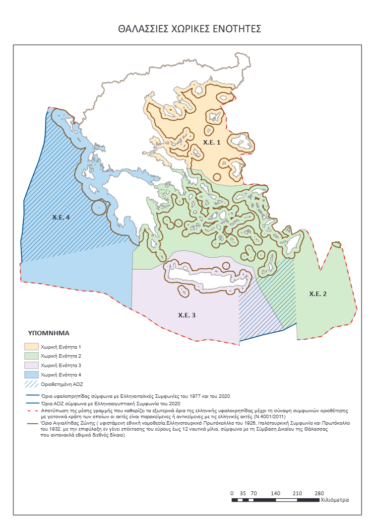
- The map with the maritime spatial units:
Ministry of National Infrastructure: Questions and answers on Marine Spatial Planning
- 1. What is maritime spatial planning?
The Marine Spatial Planning (MSP) reflects human activities in all the maritime zones of our country, with a view to protecting the environment in them.
At the same time, it determines the compatibility and parallel development of these activities, always guided by the sustainable development of marine areas and the exploitation of marine resources. The geographical scope of application of the maritime spatial planning was determined in accordance with the applicable legislation of the European Union and with the International Law of the Sea, in particular with the United Nations Convention on the Law of the Sea (UNCLOS) .
This procedure is provided for in Directive 2014/89/EU and thus fulfils our country’s European obligation. The correct transposition of the Directive into national law is essential for the development of a sustainable blue economy, the sustainable management of marine resources and the preservation of healthy marine ecosystems and biodiversity, within the framework of the European Green Deal .
It is worth noting that this directive does not affect the sovereign rights and jurisdiction of Member States over maritime waters, which derive from the relevant provisions of international law, in particular from UNCLOS .
2. What is its goal?
The organization of the marine space, the smooth interaction of land and marine activities, with the aim of environmental protection and sustainable development. When preparing the MSP, social, economic, energy and environmental parameters will be taken into account, for activities such as:
– the protection of the marine environment from the impacts of climate change – among other things – through the designation of marine parks ,
– the preservation of our cultural heritage and especially underwater antiquities ,
– the improvement and protection of maritime transport ,
– sustainable tourism development ,
– the exploitation of the country’s energy resources and especially the potential natural gas deposits and our offshore wind farms ,
– fish farming ,
– the strengthening of cross-border infrastructures of common interest with other member states of the European Union and its immediate region .
Marine spatial planning allows for a coordinated – and not fragmented – demarcation of human activities.
The correct transposition of the directive into national law is essential for the development of a sustainable blue economy, the sustainable use of marine resources and the preservation of healthy marine ecosystems and biodiversity, within the framework of the European Green Deal.
Following the strategic priorities set by the Prime Minister at the 9th “Our Ocean Conference”, the Plan is part of a holistic spatial planning policy for the country at sea and on land, which is progressively being implemented by the Greek Government.
- 3. Why is the maritime spatial planning being submitted now?
The Maritime Spatial Planning is a Roadmap for the exploitation of our marine resources . Consequently, its design was the subject of extensive consultation with relevant Ministries, local government bodies, as well as local communities. The MSP acquires even greater value when it is taken into account that our country has the longest coastline in the European Union and the most registered islands.
4. Why was maritime spatial planning divided into 4 spatial units?
Because, in this way, the administrative structure of the respective Regions is depicted . The publication of the corresponding maritime spatial planning frameworks will follow, as happened with the Regional Spatial Planning Frameworks (12 out of a total of 13 have already been published, while the 13th is underway).
- 5. Where is the maritime spatial planning published? How will citizens be informed?
It is published in the Official Gazette, as provided for in Greece, the European Union is informed and posted on its relevant online platforms. At the same time, there will be information actions by the Ministry of Economic Affairs and Energy.
6. Does the MSP have geopolitical significance?
The geographical scope of application of maritime spatial planning was determined in accordance with applicable Union legislation and international law of the sea, in particular the United Nations Convention on the Law of the Sea (UNCLOS).
It is the first time that the limits of the Greek continental shelf, i.e. the full influence of the mainland and the islands, have been reflected in an official EU regulatory text.
Maritime spatial planning implements a series of European strategies and is part of the European acquis.
Foreign Ministry: The map depicting the Greek MSP does not constitute an EEZ delimitation
- 1. Why is the training, specialization and mapping of Marine Spatial Planning (MSP) an important move?
It is the first time that the outermost potential limits of the Greek continental shelf (i.e. the full influence of the mainland and the islands in maritime zones) are reflected in an official EU regulatory text.
- 2. So what does the map depict?
The maritime areas depicted on the map include the Greek-Italian EEZ delimitation agreements of 1977 and 2020 and the Greek-Egyptian agreement of 2020, while they coincide with the boundaries deriving from Law 4001/2011.
With regard to undemarcated areas, the median line that defines the outer limit of the Greek continental shelf is drawn, until delimitation agreements are concluded with neighboring states whose coasts are adjacent to or opposite the Greek coasts.
- 3. So the map depicts Greece’s EEZ throughout the entire Greek territory (in the Ionian Sea, the Aegean Sea and the Eastern Mediterranean)?
The process of delimiting marine zones has a different subject matter from maritime spatial planning , which concerns the process by which the competent authorities of the member states analyze and organize human activities in the above marine areas to achieve ecological, economic and social objectives.
Therefore, the map depicting the Greek Maritime Spatial Planning does not constitute an EEZ delimitation.
- 4. Does it reflect the expansion of the Greek territorial sea to 12 nautical miles (in the Aegean and the Eastern Mediterranean)?
The extension of territorial waters up to 12 nautical miles is an inalienable right of our country deriving from the United Nations Convention on the Law of the Sea. It is a right that Greece reserves for its exercise when and as it deems it to be in its national interest, based on the rules deriving from International Law .
- 5. How is the preparation of Maritime Spatial Planning linked to sovereignty and the exercise of sovereign rights?
Maritime Spatial Planning and its specialization with a map is a recording of activities in all the maritime zones of the country – not an exercise of sovereign rights . Sovereignty is not a subject of planning. It pre-exists and is not affected by it.
- 6. Why is the government submitting the Marine Spatial Planning now?
The government is closing past issues. It is defending national interests in practice and in a substantive way, not with communication flares.
- 7. The preparation of the MSP is likely to provoke a reaction from Turkey. So are you abandoning the Greek-Turkish dialogue?
The fact that we are resolving past issues does not mean that we do not seek Greek-Turkish dialogue. The fact that we disagree does not mean that we do not discuss. The fact that we discuss does not mean that we make concessions from our positions and this is proven in practice. Greece desires a positive climate in relations with Turkey and has been in favor of Greek-Turkish understanding based on International Law and good neighborliness from the beginning .
Moreover, Maritime Spatial Planning concerns a substantial obligation of our country towards the EU that stems from specific European directives and is part of the framework for achieving a series of European Strategies, such as the Green Deal and the European Maritime Security Strategy (EUMSS-EU Maritime Security Strategy).
















Επιτελους η Κυβερνηση εφαρμοζει την εντολη της ΕΕ για καθορισμο της θαλασσιας εκτασης ευθυνης της συμμφωνα με το Διεθνες Δικαιο το οποιο παραβιαζε μεχρι σημερα και πληρωνε καθε χρονο προστιμο στην ΕΕ για μη συμμορφωση της!