


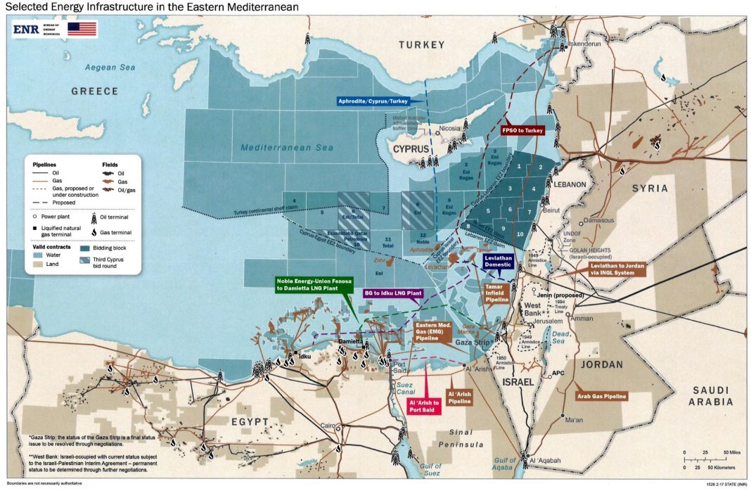
PHOTO: This is the infamous Biden Map, an evolution of the 1964 Acheson Plan. It shows clearly Kastelorizo and much of Cypriot EEZ under Turkey…
ΕΛΛΗΝΙΚΟ ΠΡΩΤΟΤΥΠΟ ΚΕΙΜΕΝΟ ΑΚΟΛΟΥΘΕΙ
EDITOR’S NOTE (Nick Stamatakis). This is an excellent comprehensive analysis by our friends at i-epikaira.blogspot.com of what is at stake regarding the sovereign rights of Greece and Cyprus, as they are threatened not simply by Turkey but by the plans of the American Deep State and the Globalists behind it. Their single-minded goal is to defeat Russia and grab for free its untold riches in mineral wealth ($70T – yes trillion with a “T” – is the value of the known mineral reserves owned by Russia, the total real value is several times this number)!! To achieve their goal they have to satisfy the insatiable, corrupt “pashas” of Ankara, so to attract them back to the West. No, they will not do it by printing more dollars. They will take much of Greece’s and Cyprus’s sovereign rights (which contain substantial mineral wealth) and give them to Turkey!! They have been trying for 60 straight years to achieve this goal (since the 1964 first introduction of the Acheson Plan). Now they have come very close: most Greek and Cypriot “leaders” are their pawns, including the ones who present themselves as “leaders” and “lobbyists” in our community!! And they use them to placate the noisy patriotic side. Do you think I am exaggerating? If you do, then consider the CIA’s assassination attempt against the then prime minister Costas Karamanlis in 2008 – the infamous “Pythia Pkan”. The case was “hushed” in court a few years ago, but the evidence has seen the light, and the truth is out. The stakes have never been higher for the sovereign rights of Greece and Cyprus. They, the American Deep State, have to answer to all of us WHY GREECE SHOULD BE THE ONLY COUNTRY ON EARTH THAT DOES NOT HAVE A 12-MILE TERRITORIAL WATER ZONE.
This is a rather long article but it can be used as a guide, especially by those of you who give donations to any Congressman or Senator. The principles to push and the questions to ask: 1) A 12-mile territorial water zone for Greece. 2) Unified EEZ between Greece and Cyprus. 3) Apply to Greece and Cyprus the same “Law of the Seas” principles that the U.S. applied in delineating sovereign rights with Cuba and the Bahamas, both island nations.
EACH OF YOU HAVE TO DO IT. DO NOT EXPECT ANYTHING FROM OUR LOBBYISTS AND “LEADERS”, ESPECIALLY THE CYPRIOT AMERICANS. THEY ARE ACTING LIKE AGENTS OF THE STATE DEPARTMENT AND OTHER INTERESTS.
============
The creation of a “neutral zone” in the Aegean, the loss of the Southern Mediterranean and the national mutilation
iEpikaira.- (published 12:26-29/03/24, updated 22:45-29/03/24) This article presents evidence that sheds light on the background of a looming plan to redraw the maritime borders between Greece, Turkey and Cyprus. The Aegean and the Eastern Mediterranean are examined separately, but it turns out that they are part of the “High Strategy” of the United States, which is being implemented step by step.
The Aegean
Starting from the Aegean, if we wanted to be more specific, we would say that we are not talking about “redrawing” but about “erasing” the existing borders and creating a corridor that will be considered as an “International Strait” and not as a “Sea” in which both coastal states exercise rights.
Professor Ioannis Mazis, in June 1997, argued that “the Aegean will not belong to Greece as an Area of Responsibility, but we will be responsible [only] for the defense of our islands and our territorial waters” and adds, “it is obvious that the concept of the Area of Responsibility in the form of command and control that we have known and that NATO, relying on the Turkish involvements, prevented us from acquiring, is significantly degraded with the new architecture of the Alliance. In maritime operations, the so-called Task Forces Concept will be applied, according to which NATO forces will act dominantly in the central Aegean, over which they will also have operational control. In the issues of air defense and information exchange (Cross Tel) it is almost certain that the Turks will try to push the geographical border of Information Exchange in the middle of the Aegean! Something like this would mean, if accepted of course, the loss of the Aegean.”
The well-informed Manolis Kottakis wrote in “Estia” in August 2020 (republished in March 2022):
“My reliable source on the other side of the Atlantic informed me at an unsuspected time, the EEZ segmental delimitation agreement between Greece and Egypt had not even been signed, of her confidential conversation with a high-ranking member of the US Congress. The reliable source of mine reported that the Congressman interlocutor conveyed to her the assessment that a Peace Agreement between Greece and Turkey is being conceived by which Greece will be invited:
1. To expressly give up by international treaty its right to extend its territorial waters to 12 miles in the Aegean. The declaration of Madrid, which led to the suspension of the exercise of the Greek sovereign right for 23 years, is no longer enough. Its institutionalization is requested. The Americans even argue that even if our extension to 12 miles were possible, Greece does not have a sufficient number of forces to carry out patrols either on warships or on commercial ships (submarines, warships). So let’s settle for the “selective expansion” according to Simitis. Somewhere 10, somewhere 8, somewhere 6.
2. It will be called upon by bilateral agreement or arbitration to withdraw its troops from the Aegean islands with the simultaneous retreat of the Fourth Army from Smyrna to the Turkish hinterland.
The goal of such an agreement would be, according to the congressman, to create a “neutral zone” west of our 28 supposedly demilitarized islands. Neutral to serve international navigation between Suez and the Dardanelles.”
Pressures for 12 nautical miles territorial waters
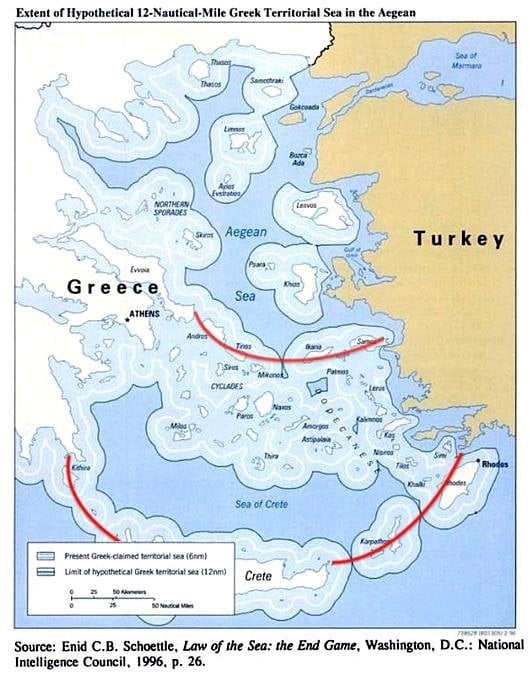
militaire.gr wrote on 03/21/22: “The senator’s cynical confession is partially confirmed by Admiral Christos Lymberis, who has publicly stated that: “What I experienced so much in November 1994 [when the international convention on the Law of the Sea came into force which allows the extension of the territorial sea to 12 nm] as well as in January 1996 [pp. Imia] was the burdensome pressure on the part of the US to NOT exercise the right to extend the Aegialitis Zone. Thus, Athens renounced the use of a strategic weapon, both in the active phase of the crisis during the mediation and in the political dialogue that followed the de-escalation”. The Admiral, then head of the Greek Navy, in his briefing to the Greek Ministry of Foreign Affairs, even stated that: “The Americans argue that the expansion of our territorial waters will negatively affect American naval operations, because Greece refuses to accept all the straits that are formed as subject to the Free Transit Passage regime and the harmless passage regime will be maintained. What will this mean for Americans? First, US submarines will surface in straits that are not designated as international. Second, American aircraft will be prohibited from overflying these straits and thus will be forced to seek the consent of Athens… I have learned of American instructions to their submarines, which specifically identified five straits in the Aegean as ‘straits of free passage'”. »
It is clarified here that the geostrategic value of the Aegean is based on the control of the “Greek Straits”. Beyond their obvious value as a trade/energy corridor, the British Michael McGuire once wrote that “in wartime, the Black Sea becomes a grenade in Russia’s straits” and in this sense, the “Greek Straits” are the fork .
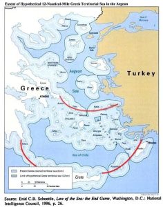
Map of Greek Territorial Waters Zone with 6 and 12 nm: Red arcs have been added to the “narrows” created by the extension to 12 nm. Source: Enid C.B. Schoettle “Law of the Sea: The End Game”, 1996, pp. 26. Source: ethnos.gr
To the above revelations was added the reference of Kyriakos Mitsotakis who “discovered” in the years 2023 the existence of “NATO islands” (1, 2), and indirectly implied the looming assignment of sovereignty (“living space”) in the Aegean. This is a clear undermining of the Treaty of Lausanne that Tayyip Erdoğan forcefully puts in the public debate by instrumentalizing the aggressive and revisionist doctrine of the “Blue Homeland” – whose foundations were laid since the 70s -, together with the prothymos in Greece (1, 2, 3) and the well-known fifth phalanx of “Greek-Turkish friendship” (1, 2, 3). In fact, many characterize the pending Greek-Turkish agreement as the “Prespes of the Aegean – Southern Mediterranean”, for which most of the political system bears responsibility, especially those who ruled the country in the post-colonial period.
Also, in the light of the above, the deeper reason why Turkey sought and achieved the dual name for the Dardanelles Straits (1, 2) on NATO maps and now also referred to as “Turkish Straits” is explained. In this way, it indirectly secures the sovereignty of the Straits, when/if the plan to create a “neutral zone” in the Aegean is implemented.
The Eastern Mediterranean
After sketching the picture of what is going to happen in the Aegean, we will move to the Eastern Mediterranean, for which the extraordinary Biden map has already been leaked since 2019, which:
-neutralizes the map of Seville,
-captures his claims were indicated by Turkey to the Americans, and
-is at an advanced stage of implementation.
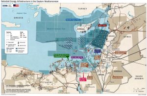
Biden map. Source: mcclatchydc.com
In more detail, in a previous article (15/10/22) we wrote: “The “prophetic” Biden map (first highlighted by Marios Poulados “Simerini Kyprous”, 11/06/2019), was mapped by state cartographers and diplomatic experts energy under the instructions of the then Vice President Joe Biden, from the State Department’s Bureau of Energy Resources. Among the many paradoxes it presents are the following:
-Describes in detail the southeastern limits of the supposed “Turkish continental shelf” as submitted to the UN (18/05/2020), except for the provisions of the Turkish-Libyan pseudo-memorandum.
-It does not capture the EastMed pipeline (see iEpikaira’s detailed analysis) but envisages a natural gas pipeline through Turkey which is a constant request/pursuit of the neighbor.
-Eliminates the influence of the Kastelorizo complex in the EEZ, i.e. gives Turkey all the EEZ east of the 28th Meridian that intersects Rhodes [an area in which Oruc Reis carried out illegal surveys for 4.5 months and was not included in the Greek-Egyptian EEZ delimitation agreement . It is noted that Turkey had licensed research to TPAO since the 70s in the area in question]…
–It shows strong signs of annexation of the possessed.”
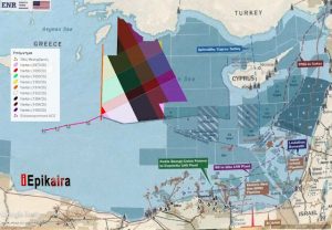
Comparison of the Biden map (with the memo deleted for clarity) with the illegal Turkish Navtex surveys of Oruc Reis and the Greek-Egyptian EEZ (A,B,C,D,E) segmental demarcation. Near point A the 28th Meridian.
The Doctrine of a Unified Defense Area
At this point it is pointed out that the Doctrine of the Unified Defense Area (USD) opposes the provisions of the Biden map and is therefore a “red flag”. It was abandoned at the urging of the Americans and after pressure from the Turks, as you will see in the following secret telegram (topontiki.gr, 31/08/23) of the Greek Ministry of Foreign Affairs (September 18, 2001). There the Americans are putting obstacles in the preeminent exercise of consolidation/consolidation of the Doctrine between Greece and the Republic of Cyprus, which had the code name “Nikiphoros”.
“A7 ADDRESS
Subject: Exercise Nikiforos
During today’s visit by the American Chargé d’Affaires to Mr. Deputy Minister, Mr. Cleverly reported that instructions had been given to raise to the highest possible level in Athens, Nicosia, and Ankara the American concern for the possibility of an accidental and unintended accident during the coming “Nikeforos” exercise. Mr. Cleverly mentioned that in the past an effort had been made to build confidence measures between Greece and Turkey to avoid unpleasant consequences. Under the current circumstances, he added, when everyone’s attention is focused on the concerted effort to suppress terrorism and cohesion is required, any mishap will create unpleasant consequences. Mr. Cleverly provided yet another potentially unfavorable dimension. He said that in the event of an unavoidable accident, Denktash would take advantage of the event to further hinder the efforts of the UN.
The present Political Adviser, Mr. Kiesling, clarified that the US does not propose to cancel the exercise, but urges for the demonstration of ”moderation” and that the Turks are willing to respond ”in a restrained and reciprocated manner”, a fact which testifies that the information of the Turks preceded it.”
By gradually abandoning the IDF, the Simitis government undermined the security of Kastellorizos as a link between Greek and Cypriot maritime space, allowing Turkey in 2012 to make specific claims in the area, which were heard by the State Department and taken into account and on the Biden map (2015-2017).
Simultaneously with the deactivation of the IDF, NATO erased from its maps the borders on the Greek-Turkish sea border, as is established by another secret telegram (topontiki.gr, 31/08/23) of the Greek Ministry of Foreign Affairs (December 2001), which confirms the implicit intention to re-engrave them:
“Address Aeronautical Department
Subject: Erasure of maritime borders between Greece and Turkey on NATO maps
As GEETHA (Greek Pentagon) informed us, our country, after signing a relevant agreement in 1996, with the US Geographical Service (National Imagery and Mapping Agency/NIMA/USA) participates in the 1:250,000 scale digital / vector map training program (VMAP). Turkey also participates in this program.
These maps have been agreed to depict the elements contained in the current NATO analog (paper) maps, many of which have been drawn up in 1973 by NIMA. Five (5) of the maps in question (two editions in 1973 and the third edition in 1983) depict the Greek and Turkish territory and depict the line of the maritime border between Greece and Turkey.
During the meeting of the VMAP Steering Committee, in May 2001, the US presidency proposed to the Greek side not to display the Greece-Turkey sea border on the digital map it has undertaken to prepare. He also stated that he is oriented to the revision of the common maps, so that the maritime borders in question are not depicted, following a relevant suggestion from the State Department.
After the reaction of the Greek side (in accordance with instructions from the Ministry of Foreign Affairs), NIMA proceeded, in June 2001, unilaterally and without observing the procedures provided by NATO’s Geographical Policy, i.e. without prior information from NATO, nor prior cooperation with the countries whose territory is depicted, in a revision, in the context of NATO, of four analog (paper) maps of Joint Operations Graphic-Air/JOG-A, erasing the sea borders of Greece – Turkey, as they are depicted on the maps of 1973.
According to the argument of the American side, the revision of these maps was done at the behest of the State Department, which is allegedly unaware of the existence of conditions defining the maritime borders of Greece and Turkey acceptable to both countries. Moreover, as an impartial third party, he does not wish to take a position on the conflicting views of Greece and Turkey in this matter. Finally, the aforementioned revision is due to a decision by the US not to depict maritime borders in general on maps of this type.
According to what GEETHA informed us verbally, the procedure followed in order to use maps within the framework of NATO, is their official circulation by NIMA in the Organization’s countries. At the same time, the USA includes them in its annual publication, the “Geostar A”, which they send to all NATO authorities. Once the maps are released and published as above, possible objections of a country can be presented at the NATO Geographic Conference, which meets once a year (June), and in which all member countries participate, while decisions are made with unanimity. Therefore, our subsequent protest at the NATO Geographical Conference will not only be fruitless (due to the unanimity principle), but will also be an opportunity for Turkey to raise the issue of “Greek-Turkish border disputes”, within the framework of a NATO body. Most likely, the issue will be referred for resolution at a bilateral level, between the Greek and Turkish sides.
From the above, it becomes obvious that the establishment of the maps in question within the framework of NATO will seriously harm our national interests and will create an issue of our “border disputes” with Turkey and a questionable precedent for other similar or related actions in the future.”
In summary, the US Geographical Service (National Imagery and Mapping Agency/NIMA) after a suggestion from the State Department, disappeared the Greek-Turkish sea border in 2001. What message was given to the Turks with this action? But let’s go further back in time, so that the puzzle of the American plan can be completed. On 10/15/22 this step published an article under the headline: “Biden map is the evolution of ‘Acheson plan’ and is in final stages of implementation!”, from which we copy an excerpt:
The Acheson Trap
“In the book by Professor Theodoros Karyotis “Exclusive Economic Zone” (2019), it is pointed out that the biggest problem facing Hellenism is the attitude of the USA regarding the issue of co-exploitation-co-management of hydrocarbons in the Eastern Mediterranean, as they are constantly trying to find the appropriate formula to assign a part of it to Turkey. This is exactly what the intervention [of former American Foreign Minister Dean Acheson was aiming for. It is clarified that this is not a specific “American Plan” although it is commonly called that, but was in fact a series of exploratory proposals, under the supervision of the Foreign Office]. According to the professor, Acheson’s proposal was very carefully considered. The Americans knew that Kastellorizo was a key problem but also a “golden fleece”. [Thus the Acheson proposal included a long-term lease of the Megistis complex from the Turks. The Americans] found out early on that without Kastellorizo, Turkey is completely cut off from the Southern Mediterranean as well as the rich deposits of the area which they had since then estimated and methodized their division (1, 2, 3, 4, 5). Exactly 50 years after Atcheson, American diplomacy returned to the issue and issued the well-known Biden map. […]
Biden map similarities with Acheson proposal
– It is obvious that the Biden map assigns to Turkey the Greek sovereign rights east of the 28th Meridian or even the Megistis complex itself, with the formula proposed by Acheson.
– The Biden map has indications of annexation of the occupied which are more than obvious in Karpasia, as the Acheson proposal also predicted (on a smaller scale, but the proposal was made 10 years before 1974). It is also no coincidence that Turkey now insists on the two-state solution, which will possibly be a safeguard against annexation. It is clarified that the Biden map was disclosed to Turkish President RT Erdogan between 2015-2017 [-or less likely late 2014].”
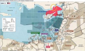
Indications of annexation of holdings on the Biden map. With red shading is the “potential” EEZ of the occupied (no sea zone!). Circled in yellow an imaginary corridor/bridge connecting it to the coastline/baseline of mainland Turkey. Source: slpress.gr
Timeline of undermining Greek sovereign rights
Before the Acheson proposal, however, the exception of Leros from the NATO plans was preceded in 1957 by the first Secretary General of NATO, Hastings Ismay, following a Turkish demand. Then, Dean Acheson in 1964 pushed for the Turkish TPAO’s illegal permits, starting in 1973 and running consecutively until the end of 2012 (note that the 2012 permits have a west limit at the 28th Meridian, as does the Biden map) , but also the invasion of 1974. In 1980, Joseph Luns issued the famous “Policy Directives for the Aegean Islands” which imposed the exclusion of Lemnos from the construction of NATO infrastructure projects. The next step was the elimination of the Greek-Turkish maritime border from NATO maps in 2001. In 2006, the Supreme Military Commander of the Alliance, General James Jones, exempted all the “demilitarized” – according to the Turkish narrative – islands from NATO exercises.
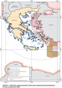
Map of Turkish TPAO illegal permits from 1973 to the end of 2012. The 2012 permits have a west limit at the 28th Meridian, as does the Biden map. Source Greek Ministry of Foreign Affairs: mfa.gr
After the intention was cemented, the new theoretical maritime borders were then marked on the Biden map (2015 – 2017), solemnly graying out the entire Southern Mediterranean. An area which in 2020 Oruc Reis plowed, achieving a feat on the field that will be difficult to undo, with the Greek Armed Forces having been instructed to monitor discreetly and from a distance.
It is recalled that the illegal searches were carried out in the maritime area that cuts off the common sea border between Greece and the Republic of Cyprus and also in the passage of the EastMed (the one that the US “emptied” with the non-paper which – for the record – was leaked in January 2022 but it was speculated to have been distributed in October-November 2021 and had a strong Turkish flavor [1, 2, 3]).
The announcement of the State Department at that time spoke for the first time about investigations in “disputed waters”, which came to complement the statement of the former British Foreign Secretary Sir Alan Duncan on 14/05/19, regarding the illegal Turkish drilling in Cypriot EEZ when he said: “Exploratory drilling should not be conducted in any area where sovereignty is in question.”
The redrawing of the borders at sea also affects the air – without going into details about saving space -. As this step already discussed (20/03/24), the novel addition of “Sky” to the “Blue Homeland” doctrine means that the maritime borders will coincide with the FIR.
What is the purpose of the border change?
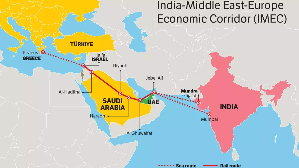
To the question of the purpose of changing the borders in the Aegean and the Southern Mediterranean, the answer was given with the announcement of the connecting route between Europe and the Indian Ocean, through the Southern Mediterranean and the Aegean, the Economic Corridor India-M. East-Europe (IMEC).
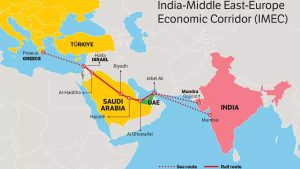
IMEC: India – Middle East – Europe Economic Corridor
Since the announcement refers to the port of Piraeus as the gateway to the EU, it is not excluded that Alexandroupolis will be chosen in the end. After all, there are not a few who talk about the creation of an EEZ on the Evros (1, 2, 3), which on the one hand would allow easier control of the economic corridor by third parties and on the other hand would connect IMEC with the US-inspired “Three Seas Initiative” which ends in the Baltic which has now turned into a “Natoic lake”. All of these are individual parts of the “High Strategy of the USA” – it will not be analyzed here – which is implemented gradually, with Greece and Cyprus being in the eye of the global geopolitical cyclone.
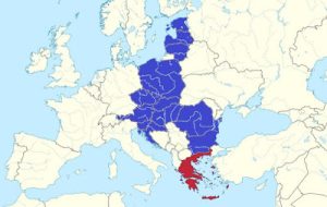
Three Seas Initiative with 12 EU Member States in Central and Eastern Europe between the Baltic, Black and Adriatic Seas. With the participation of Greece, it also gains access to the Aegean.
Findings
Panagiotis Kondylis, one of the greatest thinkers and theorists of war, in his iconic work “Theory of War” (1997), makes the grim observation that Hellenism has been shrinking continuously over the last century. He writes: “this is an extremely dense chain of national catastrophes within a period that is minimal from a historical point of view”, and explains:
“The nation finally coincided with the state, not because the state expanded, but because the nation was mutilated and shrunk, because the Hellenism of Russia (after 1919), of Asia Minor (after 1922), of the Balkans disappeared or was displaced. and the Middle East (especially after 1945). This was followed by the expulsion of Hellenism from Constantinople (1955) and Northern Cyprus (1974).
He added that “the proven inability of the Greek state to defend the Greek nation – that is, to fulfill its mission par excellence – is the most ominous sign for the future”, while he concluded that “Greece is changing
===========
Η δημιουργία «ουδέτερης ζώνης» στο Αιγαίο, η απώλεια της Αν. Μεσογείου και ο εθνικός ακρωτηριασμός
Πηγή: i-epikaira.blogspot.com

iEpikaira.- (δημοσιεύτηκε 12:26-29/03/24, ανανεώθηκε 22:45-29/03/24) Στο παρόν πόνημα παρουσιάζονται στοιχεία που ρίχνουν φως στο παρασκήνιο ενός διαφαινόμενου σχεδίου επαναχάραξης των θαλασσίων συνόρων μεταξύ Ελλάδας, Τουρκίας και Κύπρου. Το Αιγαίο και η Αν. Μεσόγειος εξετάζονται χωριστά αλλά αποδεικνύεται ότι συναποτελούν επιμέρους ψηφίδες που εντάσσονται στην «Υψηλή Στρατηγική» των Ηνωμένων Πολιτειών η οποία υλοποιείται βαθμηδόν.

 |
| Χάρτης ελληνικής Αιγιαλίτιδας Ζώνης με 6 και 12 ν.μ.: Έγινε προσθήκη κόκκινων τόξων στα «στενά» που δημιουργούνται με την επέκταση στα 12 ν.μ.. Πηγή: Enid C.B. Schoettle «Law of the Sea: The End Game», 1996, σσ. 26. Πηγή: ethnos.gr |
 |
| Χάρτης Μπάιντεν. Πηγή: mcclatchydc.com |
 |
| Αντιπαραβολή του χάρτη Μπάιντεν (με απάλειψη του υπομνήματος για λόγους ευκρίνειας) με τις παράνομες τουρκικές Navtex ερευνών του Oruc Reis και την Ελληνοαιγυπτιακή τμηματική οριοθέτηση ΑΟΖ (A,B,C,D,E). Πλησίον του σημείου Α’ ο 28ος Μεσημβρινός. |
 |
| Eνδείξεις προσάρτησης κατεχομένων στον χάρτη Μπάιντεν. Με κόκκινη σκίαση η «δυνάμει» ΑΟΖ των κατεχομένων (χωρίς αιγιαλίτιδα ζώνη!). Με κίτρινο κύκλο ένας νοητός διάδρομος/γέφυρα που την ενώνει με την ακτογραμμή/γραμμή βάσης της ηπειρωτικής Τουρκίας. Πηγή: slpress.gr |
 |
| Χάρτης παράνομων αδειοδοτήσεων της τουρκικής TPAO από το 1973 έως το τέλος του 2012. Οι αδειοδοτήσεις του 2012 έχουν δυτικό όριο τον 28ο Μεσημβρινό, όπως και ο χάρτης Μπάιντεν. Πηγή Ελληνικό ΥΠΕΞ: mfa.gr |
 |
| IMEC: Οικονομικός Διάδρομος Ινδίας – Μέσης Ανατολής – Ευρώπης |
 |
| Πρωτοβουλία Three Seas με 12 κράτη μέλη της ΕΕ στην Κεντρική και Ανατολική Ευρώπη μεταξύ της Βαλτικής, της Μαύρης και της Αδριατικής Θάλασσας. Με την συμμετοχή της Ελλάδας αποκτά πρόσβαση και στο Αιγαίο. |
Πηγή: i-epikaira.blogspot.com
















There certainly is a national mutilation of Greece taking place. Forgive me, but I was not totally convinced Greek leaders joined the Great Reset. I guess the beautiful Greece I once knew will be carved up into many pieces by stakeholders. After reviewing this article I did a bit of my own research and found Greek House Davos. Here is a link. https://greekhousedavos.com/
Read how enthusiastic Greek government is to be part of the NWO. I don’t know how to express my feelings about this tragedy.