
source- newsbreak.gr
The Turks are planning to establish parks in the area left exposed by Greece between the Cyclades, Dodecanese and Crete! The goal is clear. They will raise the issue of territorial status for dozens of rocky islets
The communication “packaging” was perfect. The prime minister’s brief statement on marine parks in English, which is unknown to whom he was addressing, “dressed” with impressive footage from the seabed (which the government has been frequenting recently), was full of lyricism.
By Manolis Kottakis
Mr. Mitsotakis described the sea as “the silent power of Greece”, referred to the documentary “Ocean” that inspired him, made an ambiguous statement about “better management of the sea” and curiously noted that “we will redefine our relationship with it not as owners but as guardians ” (?), concluding with the heavy-handed “if we protect ourselves, we will also protect our future”.
The idyllic image of the government’s bold initiative was complemented by Ankara’s reaction, which, although it challenges our sovereign rights in the central Aegean and the eastern Mediterranean and demands co-management of closed or semi-closed seas, was received in Athens (alongside the aggressive headlines of the Turkish press) with celebration. “Irrefutable proof” that the government was finally doing something patriotic.
I wish it were so! But it is not! Quite the opposite. A simple comparison of the maps prepared by the Ministry of Foreign Affairs exactly a year ago with the final maps of the marine parks that were made public clearly demonstrates the dramatic retreat of Greek foreign policy to Turkish demands, which remain insatiable.
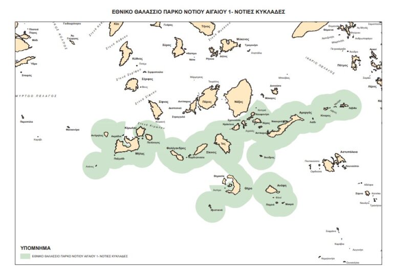
The catalytic changes in the maps are two: The first maps extended the marine parks beyond 6 miles to areas of the Aegean where Greece can, under International Law, delineate an EEZ and fishing zone. The final maps of the marine parks, which are identical to the marine spatial planning that we submitted to the EU, recently definitively enclose Greece in the 6-mile territorial waters.
They are setting precedents. The final maps also do not include the Dodecanese, except for two disputed rocky islets of Levitha and Kinaros, which the government is careful to deprive of economic life (as we have revealed). The final maps only include islands of the Cyclades, which is why the entire term Aegean has been removed from them, replaced by the term “Southern Cyclades” with the small footnote “Southern Aegean 1”. Which is a signal to Turkey that these maps do not include the areas that the Turks consider gray zones in the Dodecanese!
Now it is entirely understandable why the competent director of the Ministry of Foreign Affairs, Roussos Koundouros, was fired from his service and resigned eight months ago because this method that began with the negotiation of our sovereign rights in the heart of the Aegean on the occasion of the parks will ultimately slide (after the announcement of the Turkish marine parks in the heart of the Aegean – imminent) into a Greek-Turkish dialogue for the delimitation and reconciliation of these! In co-management in the center of the Aegean and elsewhere with the alibi of… seabirds. According to information from “demokratika”, the Turks are planning to establish parks in the area that Greece left exposed between the Cyclades, Dodecanese, and Crete! The goal is clear. They will raise the issue of territorial status for dozens of rocky islets.
This method of the Ministry of Foreign Affairs, in addition to being nationally destructive, is also strategically wrong. As the professor of International Relations at the University of Athens, Yiannis Valinakis, aptly emphasized on Naftemporiki TV: “If you really want to protect the islands and their national sovereignty, you do not prioritize the parks, but the return of the inhabitants of the islands and islets to their homes. This should be our strategic goal in the Aegean islands. The presence of people.” True. People defend their ancestral homes and not the lovable black-footed tern …